SaVoir V4.9.0

New features
1

Added swath fragmentation to cope with very large simulation periods.

Before the intersection algorithm started by creating a single swath, or set of swaths, covering the full simulation period, then testing against Areas of Interest. This could lead to out of memory crash when the user selected extremely long simulation periods (e.g. years), specially for non-sunsync satellites

Now the algorithm works on one-day batches, i.e. calculating intersections on one day slots and merging final results and testing constraints as a last step. This avoids the risk of Out of memory situations.


2

New handling of files in ESA's XML Earth Explorer file format, including file names according to EOF convention:

Import / Export EOF Zones (Areas of Interest)

Import / Export EOF Ground Station Database (Antennas)

Import EOF Swath Definition files.


3

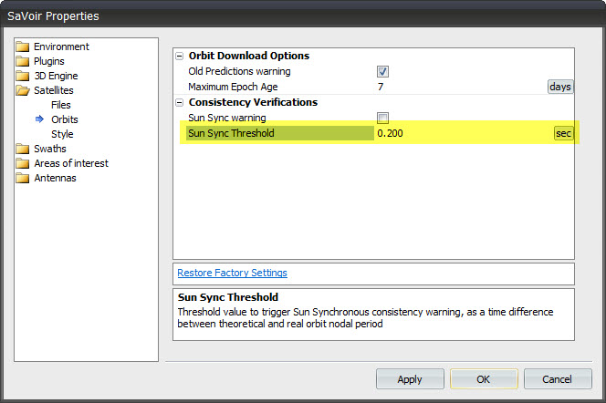
Sun sync threshold to trigger warning.

SaVoir monitors the Sun Sync orbits by comparing the theoretical nodal period resulting from the Repeat Cycle and Cycle Length and the actual orbit period from the Orbit State Vector(e.g. TLE). If the difference is higher than a given threshold the satellite will be marked with a warning icon.

This threshold has always been 0.2 seconds. Now it is configurable via the Edit / Properties dialog.


4

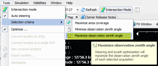
New Swath selection criteria: MAX_OZA.

In addition to existing MAX_AREA and MIN_OZA, the MAX_OZA allows to perform instrument steering and optimization selection preferring those swaths and sensor modes that maximize the Observation Zenith Angle of each acquisition.


5

New Latency calculation.

Latency is the time elapsed between data sensing and downlink to a ground station.

Now this time is calculated taking into account antenna constraints (Pass Direction, Pass Duration, and Pass Elevation) and Antenna Outage periods.


6

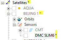
Per-facility "changed" asterisk sign.

An asterisk at the right of the name indicates a difference between the on-memory and on-file configurations.

Before this was shown at file level only, now it is shown at facility level, indicating which items have changed.


7

Min SZA added.

The Sun Zenith Angle constraint has been enhanced with a Minimum SZA parameter.

This allows, for example, to constrain an instrument to working only at night time.


8

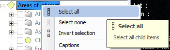
New "Select all / none" menus

Small restyling of the scenario menus providing consistent handling of facility trees.


9

Alphabetical sort prior to priority sort.

In the case of equal priorities and absence of other preference criteria between two competing sensors, areas of interest, antennas, satellites, swaths, etc, SaVoir will use alphabetical order to select items according to the item Id.

This is now imposed to avoid random selection which frequently led to different planning outputs in separate calculation sessions even if all other starting conditions were equal.


10

Priority queues.

New feature to enhance the handling of priorities in SaVoir.

Swaths generated by the intersection algorithm are given a priority value. This value is derived from the facilities that concur in generating the swath. Usually these are the Satellite, the Constellation (if applicable), the Sensor, the Sensor Mode and the Area of Interest. The priority assigned is calculated as the minimum value of the concurring priorities.

The lower the value the higher the priority, and a higher likelihood that the swath will be preferred over lower priority swaths.

In case of equal priority among competing swaths SaVoir will now explore the priority queue (Constellation->Satellite->Sensor->SensorMode->AOI) to make a decision.


11

Transition Times Max Gap added.

The Transition Times constraint is now enhanced to support configurable freewheel gaps to avoid unnecessary mode transitions.


12

New Map File format.

Small modifications to the SaVoir XML Map file formats to cope with a change in object models providing the capability to use map descriptors in non-visual SatX implementations (e.g. SatX-web). Older file formats are backwards compatible and will be read correctly. New file format cannot be read by older versions of SaVoir.


Fixed source
1

Steering candidates are now checked against constraints.

When in Auto-steering, SaVoir will select candidate sensor modes (or beams) by checking Cloud Cover, Coverage, Observation Zenith Angle and Duration Threshold constraints, and rejecting non compliant candidates, prior to their benchmark evaluation.

Before this was done as a post-calculation action resulting in incorrect benchmarks and incorrect planning.


2

Fixed overcrowding captions on Gantt view.

Before the Gantt View was easily overcrowded with too many text labels. This is now avoided.


3

Fix in GeoTIFF file ingestion.

Before SaVoir was capable of reading GeoTIFF files in the most usual projections only (e.g. Plate Carree, Mercator) . Other projections (e.g. local projections) were not handled and caused crash sometimes. This is now fixed.


4

Orbit file name in wizard.

Small fix to the Satellite Wizard, such that the orbit file name is properly read and displayed in the wizard when dealing with orbit files.


5

Orbit data serialization fix (Relative Orbit number was not saved)


6

Several fixes in the Outages editor.


7

Fixed Min Incid and Max Incid parameters in swaths. In certain conditions SaVoir assigned the same value to both parameters. This is now fixed.


8

Fixed bug on multi-threaded map download when failure to connect

This created seldom random crashes in case of missing internet connection. Should be fixed now.


9

Fixed shape file ingestion error, due to incorrect allocation and de-allocation of resources, leading to occasional crash in SaVoir 4.8.1. Should be fixed now.


10

Forced no-cached web access. In certain cases SaVoir was re-proposing a cached web input, instead of downloading an updated content, e.g. for orbit updates.


11

Transition times not applied before Optimization.

Before, Transition Times were applied prior to start optimization, creating situations in which SaVoir was unable to complete an AOI coverage when overlapping AOIs assigned to different sensors.


12

Profile boundaries improved.

Gantt plots of e.g. cumulative cover, etc, have limit boundaries if defined by constraints. These limits were not shown sometimes due to bug.


13

OZA constraints handled as absolute numbers. Before left-looking instruments were incorrectly evaluated and the constraint was not applied. Should be fixed now.


14

Fix KMZ file ingestion, when dealing with certain cases of banners and icons having no defined icon dimensions. This caused SaVoir to crash. Should be fixed now.


15

Fixed Cumulative coverage plot. on Gantt View.

Before the plot was calculated incorrectly if "Optimization per Area of Interest" was selected.

Configuration updates
1 KOMPSAT-5 orbit data is updated as per recent launch


Multisatellite Swath Planner - © Taitus Software Italia srl All rights reserved- info:  support@taitus.it