|
|

|

SaVoir V4.3.4 (29/10/2010)
| New features | |
|---|---|
| 1 | Whenever creating a new Area of Interest the user is given the option to define the AOI |
| 2 | Added support to ingest zipped Shape Files. |
| 3 |
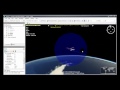
Sky Temperature sphere. Now it is possible to wrap a sphere around a satellite model where a bitmap of the Sky Temperature is projected. This allows to visualize where in the background space is the satellite sensor pointing, for example when doing black body calibrations against the background sky. Look for the new option in the Satellite / Visible properties.
|
| 4 | New parameter in the XML |
| Fixed source | |
| 1 | Fixed handling of TLE |
| 2 | Fixed ingestion of KMZ |
| 3 | Fixed persistency of Report views. Before the report state, holding information of report columns, their visible state and the column order, was not properly saved and therefore any reorganization done by the user was lost. |
| Configuration updates | |
Multisatellite Swath Planner - © Taitus Software Italia srl All rights reserved- info: support@taitus.it