|
|

|

Land
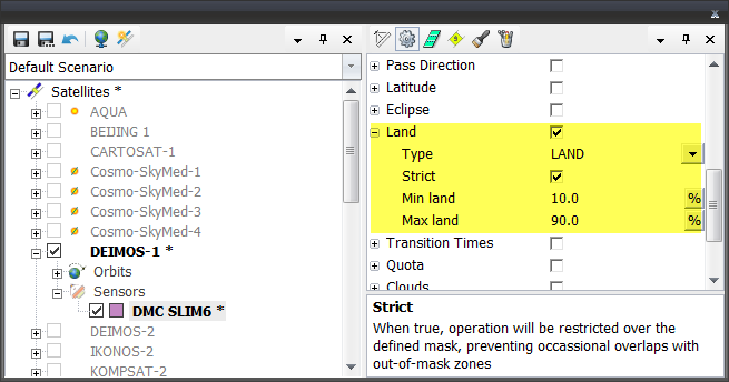
When enabled the Land constraint will ensure that sensor operations are avoided out of the land or ocean mask according to the mask type chosen.
The following mask types are available:
- LAND: Operation over land only. If Strict = false, occasional overlap with ocean and water areas is allowed.
- MARINE: Operation over ocean and water masses. If Strict = false, occasional overlap with land areas is allowed.
- NONE: Operation unconstrained, as long as minimum and maximum land cover percent limits are respected.
Strict: When true, operation will be restricted over the defined mask, preventing occasional overlaps with out-of-mask zones
It is also possible to define minimum and maximum land cover limits to the a swath:
Minimum Land : Minimum percent of land cover allowed. If the land cover for a given swath falls below the minimum the swaths will be discarded.
Maximum Land: Maximum percent of land cover allowed. If the land cover for a given swath falls above the maximum the swaths will be discarded.
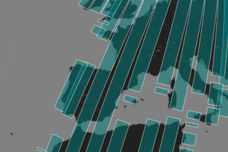
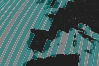
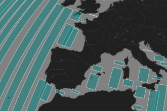
| Strict = false | Strict = true | |
|---|---|---|
| Land |
|

|
| Marine |
|
|
Land cover evaluation is done against a predefined land mask bit map, defined under Edit / Properties / Environment / Topography.
Higher resolution bitmaps can be used to allow more accurate land / ocean separation.
Multisatellite Swath Planner - © Taitus Software Italia srl All rights reserved- info: support@taitus.it